

Floods and Climate
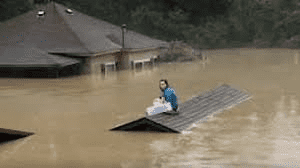
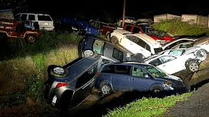
Record-breaking rainfall brought devastating flash floods and landslides to Missouri, Kentucky, and other parts of the central United States in the last week of July 2022. As noted by the Intergovernmental Panel on Climate Change and the American Meteorological Society, extreme precipitation events and weather are becoming more likely with climate change.
How much rain fell last week in the St. Louis area and eastern Kentucky? The St. Louis airport set a new record with 8.64 inches of rain in 24 hours (25 percent of the city’s annual rain fell in just 12 hours!); the previous record was set in 1915 by the remnants of a hurricane. And in eastern Kentucky a day or two later, between 8 and 10 inches of rain fell in 48 hours, and 4 more inches arrived a day later. Both storms and flash floods were so-called “one-in-1000 years” events.
And why are these extreme events happening more often? Recent events like these and scientific analyses suggest that once-rare events are becoming more likely as Earth’s atmosphere warms, which means the atmosphere can hold more moisture, and that means there’s more of it to fall out of the clouds. The scientific advances that make it possible to directly link extreme events to climate change is called attribution science, and it is one of the fastest growing areas of climate science.
Just in the past couple of months, scientists have found that climate change increased the likelihood of catastrophic floods in South Africa and deadly heat in South Asia — events that both occurred this spring. And there is little doubt that the hand of climate change will become visible when analyzing the devastating flash floods in Missouri and Kentucky. All the more reason to make Cape Ann more climate resilient so we can “weather” these more frequent and powerful storms when they happen here!